


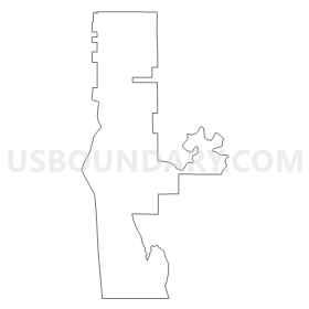
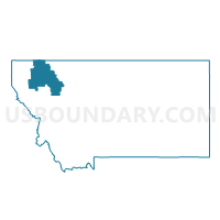
Precinct 38, Flathead County, Montana
About
Outline
Summary
| Unique Area Identifier | 611975 |
| Name | Precinct 38 |
| County | Flathead County |
| State | Montana |
| Area (square miles) | 47.80 |
| Land Area (square miles) | 29.14 |
| Water Area (square miles) | 18.66 |
| % of Land Area | 60.96 |
| % of Water Area | 39.04 |
| Latitude of the Internal Point | 48.06651110 |
| Longtitude of the Internal Point | -114.07604830 |
Maps


Graphs
Select a template below for downloading or customizing gragh for Precinct 38, Flathead County, Montana


Neighbors
Neighoring Voting District (by Name) Neighboring Voting District on the Map
- Precinct 24, Flathead County, MT
- Precinct 29, Flathead County, MT
- Precinct 42, Flathead County, MT
- Precinct 43, Flathead County, MT
Top 10 Neighboring County Subdivision (by Population) Neighboring County Subdivision on the Map
- Creston-Bigfork CCD, Flathead County, MT (8,372)
- Lakeside-Somers CCD, Flathead County, MT (5,594)
- Woods Bay-Rollins CCD, Lake County, MT (3,166)
Top 10 Neighboring Place (by Population) Neighboring Place on the Map
Top 10 Neighboring Elementary School District (by Population) Neighboring Elementary School District on the Map
- Polson Elementary School District, MT (9,949)
- Somers Elementary School District, MT (6,311)
- Bigfork Elementary School District, MT (5,747)
- Cayuse Prairie Elementary School District, MT (2,440)
- Swan River Elementary School District, MT (1,551)
- Creston Elementary School District, MT (1,180)
Top 10 Neighboring Secondary School District (by Population) Neighboring Secondary School District on the Map
- Flathead High School District, MT (57,390)
- Polson High School District, MT (11,105)
- Bigfork High School District, MT (7,462)
Top 10 Neighboring State Legislative District Lower Chamber (by Population) Neighboring State Legislative District Lower Chamber on the Map
- State House District 10, MT (13,774)
- State House District 11, MT (11,133)
- State House District 9, MT (10,874)
Top 10 Neighboring State Legislative District Upper Chamber (by Population) Neighboring State Legislative District Upper Chamber on the Map
Top 10 Neighboring 111th Congressional District (by Population) Neighboring 111th Congressional District on the Map
Top 10 Neighboring Census Tract (by Population) Neighboring Census Tract on the Map
- Census Tract 14, Flathead County, MT (5,594)
- Census Tract 13.02, Flathead County, MT (4,788)
- Census Tract 13.01, Flathead County, MT (3,228)
- Census Tract 2, Lake County, MT (1,703)
- Census Tract 1, Lake County, MT (1,463)